Map · base maps
Which base map works in the forest
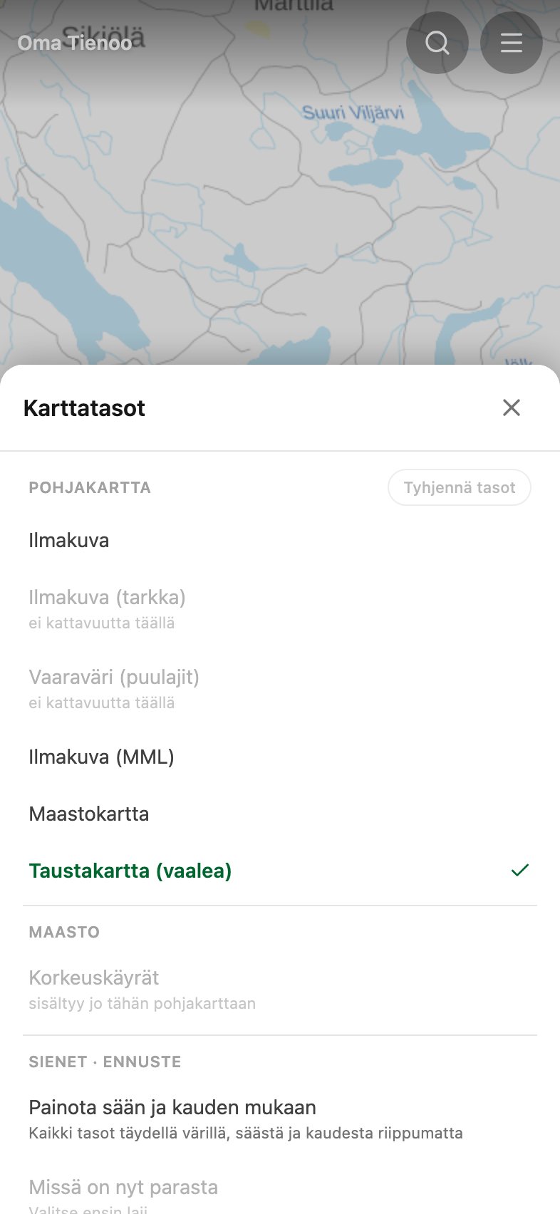
There are six base maps and exactly one is on at any time. Everything else you see on the map is drawn on top of the one you chose. The choice is not a matter of taste: the same forest looks so different on different bases that some layers stop working over the wrong one.
Taustakartta, the pale one
The National Land Survey's pale general map. Mostly white ground, with lakes and names over it. This is the one selected when you first open the app, and it is the only base over which the translucent colour of a species layer really reads. Over the topographic map or an aerial the same colour drowns in the texture. If you are looking at a mushroom map, look at it on this.
Maastokartta, the topographic map
The National Land Survey's topographic map: contours, paths, ditches, mires and buildings. This is the map you navigate by. It shows the shape of the ground that an aerial hides under the canopy, and the paths an aerial cannot resolve.
Three aerials
Ilmakuva is Esri's worldwide orthophoto and Ilmakuva (MML) is the National Land Survey's own. They are different flights from different years, and which one is sharper depends on the area. Around the capital region Esri resolves individual spruce crowns where MML is a dark navy murk, but out in the country the order can reverse. That is why both are one tap apart: compare them over the forest you actually walk.
Ilmakuva (tarkka) and Vaaraväri (puulajit) are HSY surveys and cover the capital region only. Elsewhere they appear greyed out in the list, marked ei kattavuutta täällä (no coverage here), so you cannot pick one and get an empty map. The false-colour one is infrared, where broadleaf and conifer separate into different shades, which makes it a tree species map in practice.
Contours are an addition, not a base
The Korkeuskäyrät option takes the lines from the topographic map and draws them over any aerial. It is on by default, because an aerial alone shows the canopy and not the ground you walk under it. Over the topographic map the option is greyed out, because the contours are already part of it.
Choose the base before you download an area
Downloading the map for offline use saves only the base map selected at that moment, plus the contours if they are on. If you switch base out in the forest with no signal, the new one has not been downloaded and will not draw. So choose the base first and download after. The guide covers downloading in more detail.
In short
- Mushroom layers on: the pale background map.
- Navigating in the forest: the topographic map.
- Checking what is growing on a stand: an aerial with contours on.
- In the capital region: try the sharp aerial and the false-colour one.