Map layer · forest data
Upcoming fellings on the map
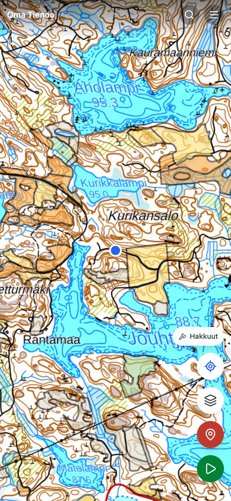
A mushroom spot does not disappear because you forgot it. It disappears because the stand was felled. The felling layer draws on the map the forest stands where a felling has been declared under a metsänkäyttöilmoitus (forest use declaration) that is still in force.
The declaration must be filed at least ten days before the felling starts. A stand therefore shows on the map before the trees go: if your own mushroom spot lands on a coloured stand, it is worth going through this autumn. And an active felling site is no place to walk.
A declaration is not a felling
This is the layer's most important limit. A metsänkäyttöilmoitus states an intention, and an intention can go unfulfilled: the Finnish Forest Centre says outright that its map service cannot tell whether a felling actually happened, since some declarations are never used and expire in three years. That is why this layer talks about declarations rather than fellings, even when a stand already looks open in the aerial photo.
Nor does every felling show. Felling for a household's own use and tending of small trees need no declaration at all, so small fellings are structurally missing. An empty spot on the map is no promise that nothing will happen there.
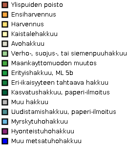
The colours are felling types
Every stand is coloured by the hakkuutapa (felling type) that was declared. For a mushroom forager the difference is large: a thinning leaves the forest a forest and can even improve conditions for kanttarelli (chanterelle), while a regeneration felling, clearcutting, takes the trees off the stand and with them the suppilovahvero (funnel chanterelle) and the boletes for a decade.
Tap a stand
A coloured stand tells you, when tapped, what has been declared for it: the hakkuutapa, the declaration date and the area in hectares. Text cannot be written onto a raster map on top of the stands, so tapping is how you get these details out in the field.
Where the data comes from
- Source
- The Finnish Forest Centre's open forest data, metsänkäyttöilmoitukset (CC BY 4.0)
- What it is
- A statutory declaration, filed 10 days to 3 years before the felling, valid for three years
- Volume
- In 2025, 131 691 declarations were filed, covering 705 823 hectares in total
- Updates
- Twice a day at the source; the map fetches the images straight from there
- Scope
- The layer shows only declarations in force. Every declaration since 2013 would cover practically all managed forest and answer nothing
How to turn the layer on
Karttatasot (map layers) → Metsätieto (forest data) → Tulevat hakkuut (upcoming fellings). The layer draws only from close enough, because the source produces no image from further out; the edge of the map then reads Hakkuut · lähemmäs (fellings, zoom closer). It works over any base map, and over the aerial photo the outlines stand out best.
The layer is meant to be read together with your own markings. The mushroom maps tell you where a species thrives; this layer tells you what is about to disappear.